


- Stock: In Stock
- Product code: 00-00012545
- Weight Brutto: 0.50kg
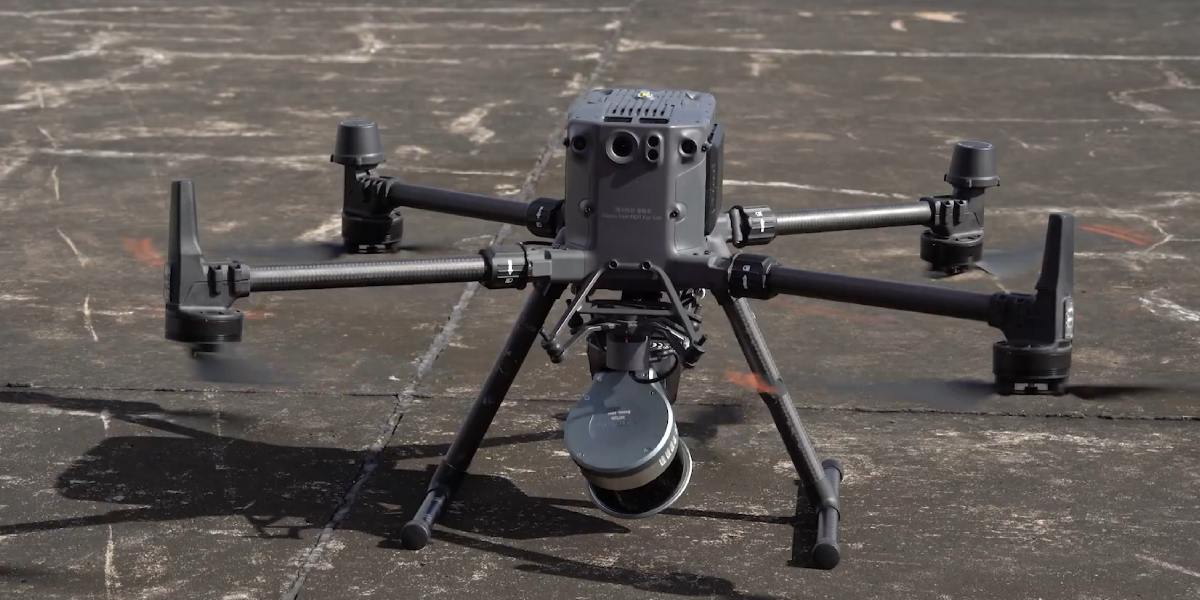
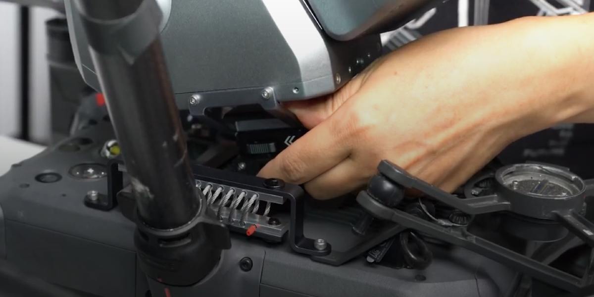
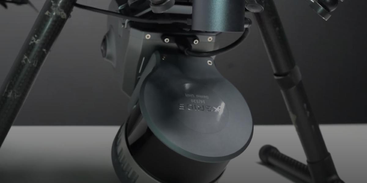
XGRIDS L2 Drone Mount: Clamp for Attaching the 3D Scanner to a Drone
The XGRIDS L2 Drone Mount (sometimes referred to as a Drone Mounting Bracket or UAV Mount) is a specialist mounting clamp designed to integrate the XGRIDS Lixel L2 Pro scanner with unmanned aerial vehicles (drones). It lifts the 3D Scanning system into the air, capturing volumetric data and Point Clouds from altitude — improving coverage and accelerating the mapping of large or hard-to-reach areas.

XGRIDS L2 Drone Mount Specifications
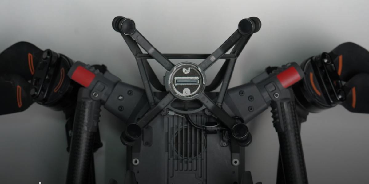
- Purpose: securing the Lixel L2 Pro to a drone / UAV, with locking mechanism and adaptation to the drone's landing gear.
- Compatible drone models: DJI Matrice 300 RTK and DJI Matrice 350 RTK are the officially declared compatible platforms.
- Mount weight: approximately 408 g (mount only, without scanner).
- Total system weight: L2 Pro scanner weight + mount, approximately 2.2 kg when using the Drone Mount.
- Flight altitude: recommended ~30 m, maximum ~50 m.
- Flight speed: recommended ~3 m/s, maximum ~5 m/s.
- Design features: vibration damping, stable mounting, low added mass, secure fixation.
Equipment Compatibility
The mount is used with:
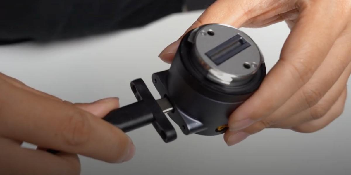
- Scanner: XGRIDS Lixel L2 Pro. This is the primary device the mount is designed for.
- Drones: DJI Matrice 300 RTK and DJI Matrice 350 RTK are officially supported.
Advantages of Using the Drone Mount
Ability to cover large areas faster and with less effort compared to ground-based or manual mapping.
Access to difficult or hazardous locations: rooftops, slopes, remote objects, forested areas that are impossible to traverse on foot.
Capturing Point Clouds from altitude allows objects to be viewed from multiple angles, reducing shadow zones and reflections, and improving visibility.
Improved overall Point Cloud geometry: flat surfaces (rooftops, floors), horizontal projections with fewer distortions.
Reduced risks and costs: fewer ground control points, less contact with difficult terrain, fewer personnel in hazardous locations.
Design Features of the XGRIDS L2 Drone Mount
Vibration Damping: the design is built to reduce the impact of drone vibration on LiDAR scan quality. This is critical, as vibrations can introduce noise and distortion into the Point Cloud.
Low added mass: approximately 408 g, which does not significantly reduce the drone's flight time.
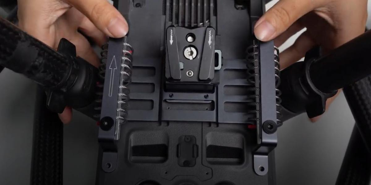
Secure scanner fixation with no play: the mount is specifically designed around the L2 Pro housing geometry to ensure a rigid hold.
Optimised attachment points, cable routing, and power adapter (where required) — everything is designed to make integration straightforward and safe (as noted in product descriptions).
Applications and Use Cases for the XGRIDS L2 Drone Mount
Where and for which tasks the Drone Mount is particularly useful:
- Aerial topographic mapping: creating digital surface models and terrain maps where ground-based scanning is impractical.
- Monitoring terrain changes, agriculture, and forestry: volume calculations, vegetation inspection, erosion monitoring.
- Infrastructure condition inspection: rooftops, bridges, power lines, communication lines, elevated structures.
- Construction and site monitoring: progress tracking, documentation of complex structures from above.
- Archaeology and cultural heritage: objects located in hard-to-reach places — aerial inspection simplifies mapping and minimises intervention.
- 3D Scanning of objects following natural disasters or in emergency conditions, where ground access is limited or dangerous.
Point Cloud Accuracy and the Solutions That Influence It
Solutions and design elements that help achieve high accuracy:
- Vibration damping minimises tremor that adds noise and point displacement.
- Rigid fixation of the L2 Pro scanner to the mount eliminates play and shifting during flight.
- Using RTK support on the drone (where the drone is equipped with RTK) together with the L2 Pro enables georeferencing of the Point Cloud in flight, reducing the need for ground control points (where the drone-RTK and RTK/Survey Grade module are installed).
- The low mass and balance of the mount help maintain stable flight and reduced motor response, which in turn reduces oscillations.
- Correct flight speed (recommended approximately 3 m/s, maximum 5 m/s) and moderate altitude (30–50 m) are the optimal conditions under which LiDAR and visual data quality remains high. At excessively high speeds or altitudes, detail and point density decrease.
Economic Viability of Using the Drone Mount
- Where a project requires mapping of large areas and ground-based methods are too slow.
- In remote-access conditions, where transporting a ground scanner or personnel is complicated, and a drone can reach the site quickly.
- For multiple projects, where the return on investment over time will be significant: lessees, companies providing mapping as a service.
- Where Point Cloud quality and georeferencing are critical, and errors in the data lead to correction costs, delays, or rework.
Performance Comparison of Different 3D Scanning Types
| Parameter | Drone Mount (with drone) | Ground-Based Mapping (tripod / ground backpack) | Manual Mode (handheld) |
|---|---|---|---|
| Area Coverage | Very high: tens of hectares in a single flight | Medium: limited by operator speed and terrain | Low: small objects, localised zones |
| Data Acquisition Speed | High: 10–20 times faster than ground-based methods | Medium: requires repositioning of scan points | Low: operator manually moves around the object |
| Level of Detail | Medium–High: optimal at an altitude of 30–50 m | Very high at close range | High at close range |
| Georeferencing Accuracy | High with RTK / Survey Grade RTK Kit | High (when using ground control points) | Medium: depends on SLAM and calibration |
| Access to Difficult Areas | Excellent: easily covers rooftops, ravines, hazardous areas | Limited: passable routes required for the operator | Limited: physical proximity required |
| Post-Processing Time | Minimal: fewer ground control points required | Medium: requires merging of multiple scans | High: frequent trajectory correction needed |
| Personnel Safety | High: operator remains at a safe distance | Medium: fieldwork can be hazardous | Low: operator is in close proximity to objects |
| Equipment Cost | Medium–High (drone + mount) | Medium (tripod, possibly RTK base) | Low: only the scanner is required |
| Optimal Application | Large areas, hard-to-reach locations, infrastructure monitoring | Architectural façades, interiors, detailed models | Rapid local mapping, mobile tasks |
You can purchase the 3D scanner mount with delivery directly via the website, or by contacting us through any of the communication channels on the Contacts page. Call us or write to us — we are keen to ensure you get the maximum benefit from working with us!


